Registration for this event is now closed.
On Sunday, December 19, BOK will host its 8th annual December Score-O, this time in Birkhead Mountains Wilderness. A “Score-O” involves a course with no predetermined route, in which competitors decide which controls they want to visit, and in which order. This event will have 2-, and 4-hour options. It is open to any orienteer or adventure racer who has successfully completed the equivalent of an advanced (orange, brown, green, red, or blue) orienteering course. You must preregister for this event here before Friday, December 17 at 5:00 PM.
This is a mass-start event, with both the 2-hour and 4-hour races beginning at 10:00 AM from the Gray Owl section of the forest. Those who prefer to start individually rather than with the group may select an early or late start time when they register. Five early and five late individual slots will be offered, and if/when they fill up, they will not be available when you register. Individuals who are unvaccinated against Covid-19 are encouraged to start individually. All runners will have a full two or four hours to complete their course, regardless of when they start. The following details, as well as any last-minute addenda will be emailed to registrants shortly before the event.
Date/Location:
Gray Owl, Asheboro NC. GPS coordinates = 35.6323794, -79.8817465
Turn on Gray Owl Road, then take the next left to enter the long gravel driveway, drive to the end, and then t nter the long gravel driveway, turn around in the circle, and then park along the east side of the driveway, facing out. Do not park in the turn-around circle or drive on the grass at all (it is soft & you will get stuck).
In addition, all the grass was overseeded this fall and the sprouts are doing nicely. Since the ground will be wet and soft, please minimise your walking on the grass, and avoid standing around on it. There is plenty of sheltered space around the house on stones and deck where you are welcome. Walk on the forest leaves and stones as much as possible.
Hot Chocolate: We will have hot chocolate at the download area. Please bring your own cup if you want to avoid using a disposable cup.
Schedule:
9:00 AM Maps available for pickup
9:45 — 10:00 AM Individual starts for those who prefer
10:00 AM Mass start (masked with 2m interpersonal separation)
10:00 — 10:15 AM Individual starts for those who prefer
12:15 PM 2-hour competition closes
2:15 PM 4-hour competition closes
Map:
The map will be printed at 1:10000 scale, on four separate letter-sized pages. The different pages will overlap by at least one inch. Please bring your own map bags/cases, as well as any materials that you use to mark up your map (e.g., tape, highlighter, distance wheel, pins, string, etc.) The map is an amalgam of several different maps, and as a result it will have quite a few quirks of which you should be aware. Most notably, the map will include the following five areas:
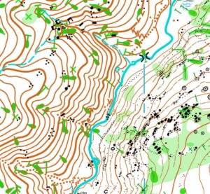
Area 1. The area in the northeast, called the Gray Owl map, has been newly mapped and field-checked by Joseph Huberman. Accuracy is extremely good, and includes downed trees. Contour interval is 2.5 meters (although there is some technical debate about the exact contour interval here.)
Area 2. A small area toward the south of Gray Owl known as the Rock Garden was mapped two years ago by Vladimir Lyuk. It was mapped for sprint events, and is exceptionally detailed and accurate, including individual downed trees. At 1:10000 scale, symbols on this portion of the map appear inappropriately small. Contour lines are thinner than on other parts of the map, and there are relatively more form lines. Contour interval matches that of the Gray Owl map — 2.5m.
Area 3. An area in the west known as the Thornburg Farm map was mapped approximately 10 years ago by Josef Trzicky and Jan Csibrei. Detail and accuracy is very good, and contour interval is 3m. Those with a very sharp eye will notice that symbols for point objects which are supposed to be north-aligned (e.g., X’s for man-made objects) are slightly misaligned. This was a mistake in the attempt to georeference this section.
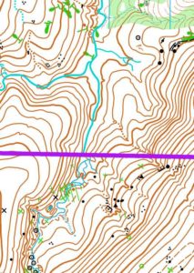
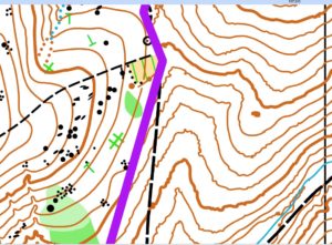
Area 4. A small area between Gray Owl and Thornburg has been partially field-checked by Joseph Huberman. This is a southern extension to the former Gray Owl map, and was not included in the attempt to georeferenced the Gray Owl map. As a result, the contour lines in this area do not match seamlessly with the Gray Owl map, and a thick magenta line covers the boundary between the areas. Contour interval is 2.5m. Point objects that are supposed to be north-aligned are slightly misaligned.
Area 5. A completely un-field checked area between the Gray Owl and Thornburg maps. This section generally only shows trails, streams, and contour lines. Contour lines are very accurate, and trails and streams are less accurate, but generally okay. Because this area is not field-checked, you may expect to see large features such as boulders, pits, thickets, etc., which are not mapped. If there are controls in this section, they will be on relatively obvious terrain features. Contour lines can appear jittery because of (obsolete) algorithms used to process lidar (thanks, OCAD v12 [sarcasm]). Contour interval is 2.5 m, which many will judge as being much too small for terrain this steep. Contour lines do not match seamlessly between other sections of the map. Boundaries between areas with mis-matching contour lines are marked (i.e., concealed) by a thick magenta line.
The following images illustrate some of the differences among these portions of the map.


The entire map is bounded by private property, and there are several private inholdings. All private property is marked with closely-space magenta lines indicating that it is out of bounds. Most of these property boundaries are not marked in the field. Some of this private property has been field-checked and included in previous events as in-bounds because the land owners have historically been unconcerned with trespassing. However, for this event, all private property is out of bounds. This will be penalized by disqualification from the event.
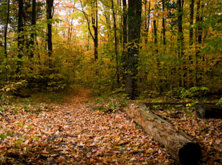
As you may expect this time of year the ground is covered with freshly fallen leaves. They do a very good job of concealing the trails. Trails will be very easy to miss if you are approaching them from the side, and smaller ones may be difficult to even follow while running.
Course and Event Notes:
The course consists of 28 controls, each worth between 3 and 8 points. On the map, controls will be marked with three digits: the first digit will be the point value of the control; the second two digits are the control code on the control box. Find as many controls as you want within the time limit for your race. The penalty for returning late is 8 points for the first minute and 1 point per minute thereafter. You cannot switch from the 2-hour to the 4-hour race to avoid a time penalty. Clearing the course can be done with less than 20km total straight-line distance between controls.
The event occurs during (gun) deer season season. Hunting is allowed in Birkhead wilderness, and hunting on Sunday has recently been allowed by the Republican-controlled NC General Assembly. My understanding of this regulation, though, is that hunting is not allowed before 12:30 PM on Sunday. It thus seems likely that participants on the 4-hour course may interact with hunters. Please wear bright orange, especially if you are doing the 4-hour course.
Drinking water will not be available on the course anywhere. Competitors — especially those in the 4-hour competition — are thus strongly encouraged to carry their own water supply or water treatment devices/methods.
